The Draa Valley: Morocco's Longest River, Its Ancient Palm Groves, and the Trade Route It Sustained
The Draa Valley: A River That Rarely Reaches the Sea and the Civilization That Grew Along It Anyway
The Oued Draa is Morocco’s longest river by measurement — 1,100 kilometers from its source in the High Atlas to its theoretical mouth on the Atlantic south of Tan-Tan — but the measurement is somewhat misleading, because the Draa in most years does not complete that adventure. The river flows strongly from the Atlas snowmelt in spring through the valley’s six oasis towns — Agdz, Zagora, Tamegroute, Tinzouline, M’hamid, and the smaller settlements between them — and then loses itself in the sand of the pre-Sahara, absorbed by the desert’s thirst before it reaches the Atlantic. In exceptional flood years, after heavy Atlas snowfall and widespread rain, the Draa’s flood pulse has reached the Atlantic. In most years, it does not.
The river’s partial adventure is the condition that created the Draa Valley’s civilization: enough water to sustain intensive palm oasis agriculture, not enough to maintain connection to the Atlantic trade networks, which meant that the valley’s external orientation was always south and east — toward the trans-Saharan trade routes — rather than north and west toward the Moroccan ports. The Draa Valley’s history is a history of the Sahara’s northern edge, not of Morocco’s Mediterranean or Atlantic face, and understanding it requires a different frame from the one appropriate to Fes or Marrakech or Essaouira.
What Is Palm Oasis Agriculture and How Does It Work in the Draa?
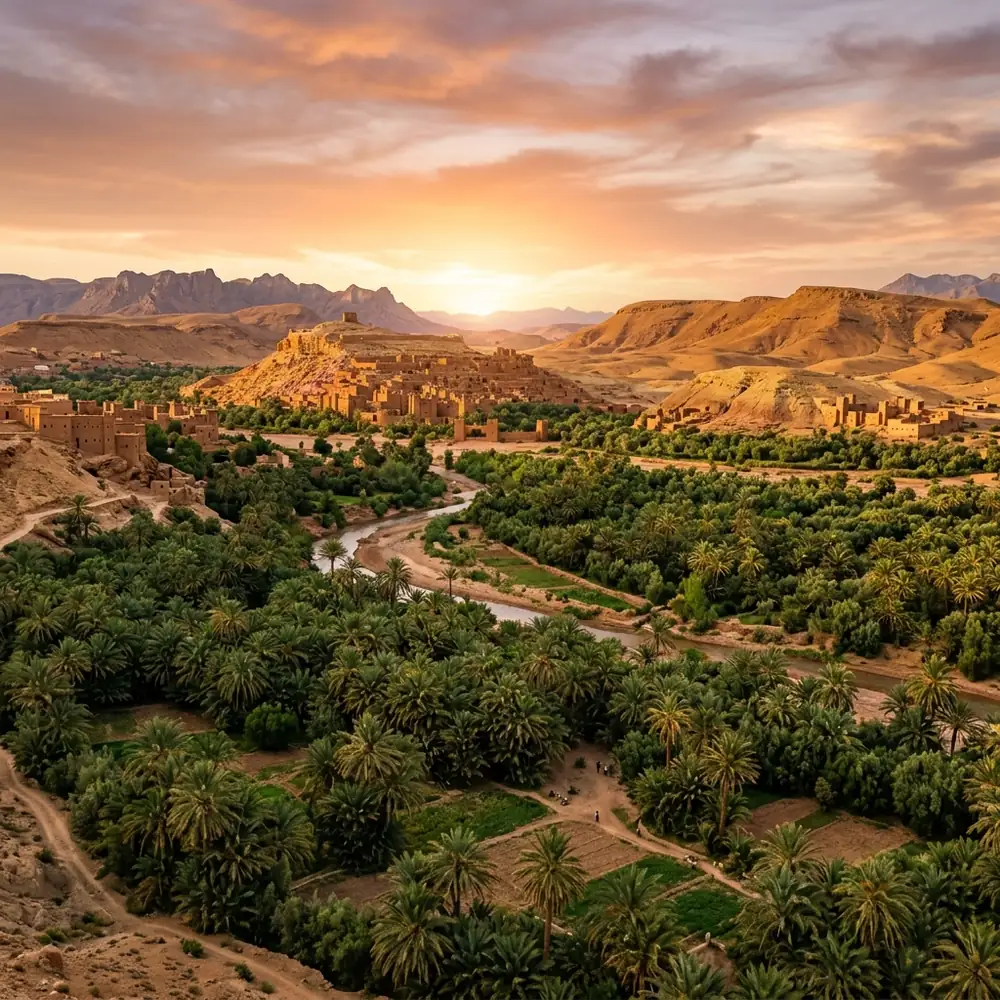
The Draa Valley’s agricultural system is the classic oasis structure of the pre-Saharan south: a vertical layering of three levels of cultivation that maximizes the use of water and creates microclimatic conditions that allow each level to thrive.
The tallest layer: date palms (Phoenix dactylifera), whose crowns form a canopy at twelve to fifteen meters that provides shade and reduces evaporation at ground level. The Draa’s date palms are the economic foundation of the valley — the medjool and other varieties grown here are exported throughout Morocco and beyond, and the palm grove’s productivity is measured in date production as much as in any other crop.
The middle layer: fruit trees — olive, fig, almond, pomegranate — whose height of three to five meters fits between the palm crowns and the ground. These trees produce fruit for both local consumption and sale, and their root systems hold the soil in the narrow garden plots between the irrigation channels.
The ground layer: vegetables, cereals, and fodder crops — henna (the Draa is one of Morocco’s primary henna-producing regions), alfalfa for the livestock, winter wheat, various vegetables in rotation. These crops use the water that the palm and fruit tree roots don’t take and the shade that the upper layers provide.
The water comes from the Draa and from the sub-surface channels (khettara) that tap the water table built up by the river’s passage. The management of this water — the allocation of irrigation turns between the different families with rights to the system, the maintenance of the channels, the governance of the overall system — is organized through traditional collective agreements that have been the social infrastructure of the oasis communities for centuries.
What Was the Draa Valley’s Role in the Trans-Saharan Trade?
The six oasis towns of the Draa Valley were the northern terminus of several significant trans-Saharan caravan routes — the routes that brought gold, slaves, ivory, and ostrich feathers north from sub-Saharan West Africa in exchange for salt (from the Saharan salt mines of Taghaza and Taodenni), cloth, and finished goods from the Moroccan cities.
The gold trade — the product that most decisively shaped the medieval Islamic world’s economy — came through the Draa at its peak in the 13th and 14th centuries, when the Mali Empire’s gold fields in the Bambuk and Bure regions were producing at their maximum rate and the trans-Saharan route through the western Sahara to the Draa Valley and thence to Marrakech and Fes was the primary conduit for that gold to reach the Mediterranean world.
Zagora — the largest of the Draa Valley’s oasis towns and the most frequently visited by contemporary travelers — was a significant waystation on this route, with the qasbah architecture that remains in and around the town reflecting the prosperity of the trade era. The famous sign on the road south of Zagora that reads “Tombouctou: 52 jours” — Timbuktu: 52 days — is a modern tourist installation rather than an ancient direction, but it accurately reflects the historical reality: from Zagora, the caravan route to Timbuktu was approximately fifty-two days of hard travel across the Sahara.
What Is the Draa Valley Like to Travel Through Now?
The drive from Ouarzazate to Zagora — approximately 165 kilometers along the N9, mostly following the valley — is one of the more beautiful drives in Morocco: the road descending from the pre-Saharan plateau into the valley, the palm groves appearing as a sudden green belt in a landscape that is otherwise ocher and rose desert, the Draa visible intermittently beside the road, the kasbah villages of pisé (rammed earth) rising from the groves at intervals.
The pisé architecture of the Draa Valley — the ksour (fortified villages) and individual kasbahs built from the local red-earth in a style that is simultaneously distinctive to the region and structurally logical for the climate — is in various states of preservation. Some ksour are inhabited and maintained; others are in the process of abandonment and slow dissolution as their inhabitants move to the modern concrete buildings that have been constructed alongside them. The traditional architecture, because it is made from earth rather than stone, dissolves when unmaintained — the rain of exceptional years and the wind of every year gradually returning the pisé to the soil it came from.
The Invisible Invitation
The road south from Agdz follows the Draa for fifty kilometers before the valley opens into the plain approaching Zagora. Stop the car at any point where a track leads down toward the palm groves and walk into the groves for fifteen minutes. The temperature drops by several degrees immediately — the evapotranspiration from the palms, the shade of the canopy, the proximity to the irrigation water all contribute to a microclimate that is distinctly cooler than the open road. The smell is specific: date palm, irrigation water on warm earth, the slight sweetness of something always growing. This is the smell of the oasis — the particular combination of green and water in a landscape that has very little of either outside the grove’s edge. Stand in it for a few minutes. The fifty-two days to Timbuktu began here. The gold came back through here. The water is still running in the channels. The palms have been here for centuries in some cases, individual trees old enough to have been producing dates when the caravans were passing through. Look up through the fronds. Stay for a while.
SEO Meta Description: What is the Draa Valley in Morocco? The oasis triple-layer agriculture, trans-Saharan gold trade through Zagora, pisé kasbah architecture, and what to do when you drive through now.
Experience the true heart of Moroccan heritage through its traditions. Join us in preserving these ancestral rituals.
What People Are Saying
No comments yet. Be the first — we'd love to hear from you.
Youssef Amazigh
A Moroccan cultural writer dedicated to documenting the authentic voice, history, and heritage of the Kingdom. Writing from within — to share what truly makes Morocco extraordinary.
Our Mission →