Jbel Toubkal: Morocco's Highest Peak, the Two-Day Summit Ascent, and What You Need to Know Before Going
Toubkal: The Highest Mountain in North Africa and the Honest Account of Climbing It
Jbel Toubkal is described in many travel accounts as "relatively easy" — a characterization that is defensible in the specific technical sense that the standard summer ascent requires no ropes, no crampons in most years between June and October, and no specialized climbing skills. It is simultaneously true that Toubkal is a 4,167-meter mountain in a remote High Atlas location, and that the combination of altitude, exposed terrain, changeable weather, and physical demand makes it a serious undertaking that claims casualties every year from trekkers who underestimate one or more of these factors.
My preference is to give you both accounts simultaneously rather than selecting one to give you false confidence or false apprehension. Toubkal is accessible to a reasonably fit person with adequate preparation and appropriate respect. It is not accessible to a person who arrives in Imlil expecting a vigorous walk.
What Is the Standard Two-Day Route and What Does It Involve?
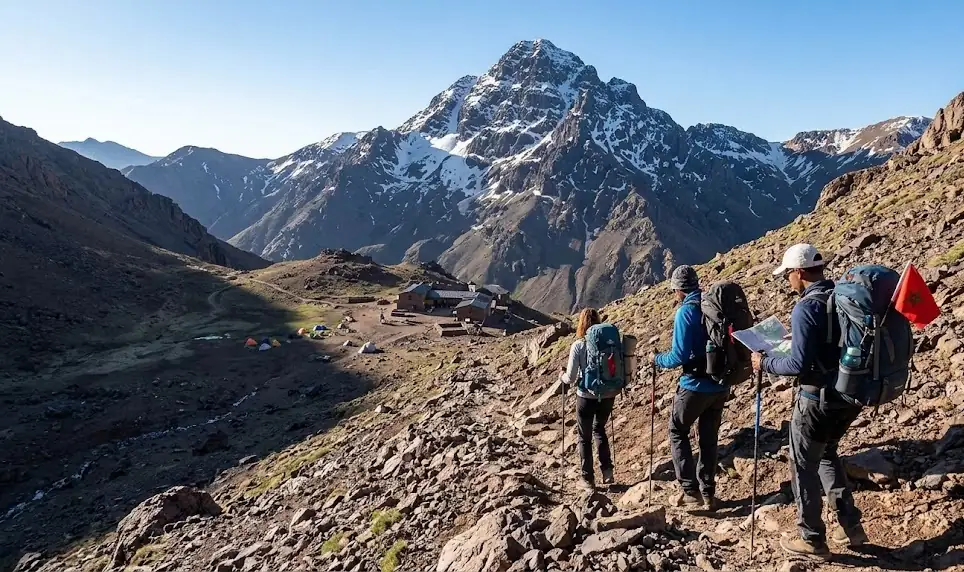
Day one: Imlil to the Toubkal Refuge. Imlil is the starting village — at approximately 1,740 meters, accessible by road from Marrakech in about an hour and a half. From Imlil, the trail ascends through the Ait Mzab valley, passing through the village of Aroumd (approximately 1,900 meters) and continuing up to the Neltner Refuge (also called the Toubkal Refuge) at approximately 3,207 meters.
This first-day stage gains approximately 1,400 meters of elevation over roughly ten kilometers of trail — a sustained ascent that takes most trekkers five to seven hours depending on pace and fitness. The trail is well-marked and well-traveled in the main season; losing the path is not the primary risk. The primary risk is overexertion in the early sections and underestimating the cumulative effect of altitude on the later sections. The Neltner Refuge provides accommodation (basic dormitory, meals, warm blankets) and is an established, functioning mountain hut.
Day two: Refuge to summit and return to Imlil. The summit ascent from the refuge gains approximately 1,000 meters over roughly four kilometers — the terrain above the refuge is rocky scree and boulder fields rather than trail in the conventional sense, requiring careful foot placement and significant physical effort. The summit push typically takes four to five hours return from the refuge.
At the summit: a cairn, a metal survey marker, and in clear conditions the view that the mountain's reputation is built on. The High Atlas visible in both directions. The Sahara apparent to the southeast — the edge of the desert visible as a color change in the landscape's hue at distance. On exceptional days, the Atlantic to the west. This view is real and it is worth the climb. It is also not guaranteed — cloud cover at summit elevation is common and can arrive rapidly. Plan for the possibility of reaching the summit in reduced visibility.
What Are the Objective Risks and How Are They Managed?
Altitude: Toubkal's summit at 4,167 meters is high enough that altitude sickness is a real possibility for trekkers ascending rapidly from sea-level or low-altitude starting points. The standard two-day route — arriving in Imlil from Marrakech and beginning the ascent the next morning — provides minimal acclimatization time. An extra day at Imlil or Aroumd before beginning the ascent significantly reduces altitude sickness risk. Symptoms to watch: persistent headache, nausea, significant fatigue beyond what the physical effort would explain, loss of appetite. The appropriate response to these symptoms is descent, not continuation.
Weather: the Atlas can produce severe weather rapidly, including thunderstorms that are genuinely dangerous on exposed terrain above 3,500 meters. The standard advice — begin the summit push early, be below the technical terrain by early afternoon — exists because afternoon thunderstorms are the statistical norm in summer months. Take it seriously.
Navigation: in winter (November through April, approximately), Toubkal is a different and more serious proposition — deep snow, potential avalanche risk, technical terrain requiring crampons and ice axes. The summer window (June through October) is when the non-technical ascent is valid. Do not attempt Toubkal in winter conditions without winter mountaineering equipment and experience.
Guides: hiring a licensed mountain guide from Imlil is not legally required and not universally done by experienced trekkers. It is strongly recommended for first-timers, adds to the local economy in ways that matter to the Atlas communities, and provides a resource that is genuinely useful in the event of weather changes, navigation uncertainty, or health issues. The guides of the Imlil region are experienced and professional.
What Is the Imlil Village and What Is the Atlas Context?
Imlil is an Amazigh village in the Ait Mzab valley whose primary economic activity has shifted significantly toward the trekking industry since the 1980s. Before the trekking economy, the valley's communities were subsistence agricultural — terraced wheat fields, fruit orchards, walnut groves — supplemented by transhumant pastoralism on the high Atlas pastures in summer.
The trekking industry has provided income that the agricultural economy alone could not sustain — guide services, mule transport, accommodation, food — and the Atlas Amazigh communities around Imlil and Ouirgane have adapted to this economy with considerable effectiveness. The guides in particular are among the most knowledgeable mountain professionals in North Africa, with multi-generational knowledge of the Atlas terrain.
The Atlas villages visible from the Toubkal trail — Aroumd, the smaller hamlets farther up the valley — maintain agricultural practice alongside the trekking economy. The terraced fields, the walnut trees, the mule transport are not tourist set-dressing; they are functioning agricultural systems that predate the trekking industry by centuries.
The Invisible Invitation
You are at the Toubkal summit cairn. It is seven in the morning — you left the refuge at five, in the dark, reaching the summit as the light was becoming full. The Atlas is visible in both directions, the ranges receding to the east and south in successive layers of ridge and valley that diminish into haze at the visible horizon. The Sahara is out there in the south-southeast — you can see where the mountain country ends and the color of the landscape changes to the ocher-brown of the pre-desert, the specific color that means no more rain, no more vegetation, no more mountains. The Atlantic is not visible today — cloud cover on the western horizon. That is fine. You are at 4,167 meters. This is the highest point in North Africa. You got here with your legs and your lungs. This is sufficient. Begin the descent while the weather is still clear.
SEO Meta Description: How to climb Jbel Toubkal Morocco? The two-day Imlil route, elevation gain, altitude sickness risks, weather management, winter vs summer conditions, and the Amazigh guide community.
Experience the true heart of Moroccan heritage through its traditions. Join us in preserving these ancestral rituals.
What People Are Saying
No comments yet. Be the first — we'd love to hear from you.
Youssef Amazigh
A Moroccan cultural writer dedicated to documenting the authentic voice, history, and heritage of the Kingdom. Writing from within — to share what truly makes Morocco extraordinary.
Our Mission →